CLOUDS AGHHHHHHHHH YAYAYAYYA!!!! Part 1
🚨CLOUD ALERT 🚨 CLOUD ALERT 🚨CLOUD ALERT 🚨
Ok. So, clouds are the reason I stayed so interested in meteorology because they are obviously the best thing in the world by far. I was going to just write one extensive blog post on clouds and post it all at once but then it was taking too long. Luckily, my wonderful mother shared some wisdom: just split it up and post it separately. So, that’s what I’m gonna do. Part 1 will cover the classic types of clouds. In Part 2, I will share more about less conventional clouds like mammatus and lenticular clouds. In Part 3, I will dive into how climate change affects clouds and vice versa. Finally, in Part 4, I will talk about other cloud stuff like how clouds can simultaneously form at different altitudes and why layers of clouds sometimes blow in different directions at the same time.
If anything, I recommend reading Part 3 because it is actually crazy how little we actually know about clouds and their relation to climate change. Recently, I was lucky enough to speak with Dr. Anthony Leiserowitz, the director of Yale Program on Climate Change Communications. During this conversation, where I was mostly awe-struck while he imparted his wisdom, he also explained that clouds are one of the biggest uncertainties in current climate modeling. Woah.
Also, sorry for not posting blogs more often, the past few weeks have been super duper busy with school and rec soccer, Model UN, end of quarter assignments, and spring break which was filled with college tours in the Northeast. There are so many colleges in the Northeast it’s insane. Anyways, back to the topic on hand.
Cloud Types
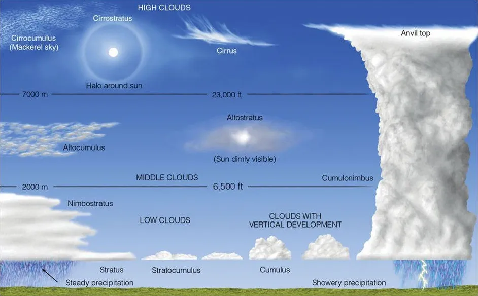
4 Categories: High, Medium, Low, and Clouds with Vertical Development. (Most clouds expand horizontally because they reach a dew point that is level throughout the sky and start condensing there.)
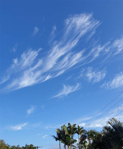
High clouds are super high up in atmosphere (right at the top of the troposphere); to the point where they can get blown across the sky by the prevailing winds! They are made up of ice crystals because it is so cold way high up in the atmosphere where they are. Finally, high clouds have the prefix cirro- which is Latin for curl of hair due to their wispy appearance.
Cirrus Clouds – these clouds can indicate the jet stream presence and where it is blowing. Also, cirrus clouds tend to precede a warm or cold front coming through so if you see them, be prepared for cloudy or rainy conditions in the next day or two. But, when the cirrus clouds are out in the sky, you won’t get rained on because even if the cloud precipitates, the snow will melt away before it reaches the ground (ZME Science).
Cirrostratus Clouds – these clouds tend to cover the sky and add a hazy look to the sky. There is no chance of precipitation from these super thin clouds.

Cirrocumulus Clouds – these clouds are easily confused with altocumulus clouds so here are the differences: cirrocumulus tend to be smaller, are found in patches, and are usually in the sky with other cirro- clouds (What’s This Cloud). There is no chance precipitation reaching you from these.

Medium clouds, as their name point out, are found between the high and low clouds. They have the prefix alto-. Yep, that’s pretty much it.
Altostratus Clouds – these gray, boring clouds that cover the sky are, in my opinion, super lame to look at. It is uncommon for them to precipitate even if they look gray and angry. If the sun does happen to shine through, it will have more of a watercolor look to it compared to cirrostratus which are much more transparent.

Altocumulus Clouds – much more fun to look at than their alto- counterpart, altocumulus clouds are some of the most diverse of the cloud types with so many different shapes and patterns. Also, the much-loved lenticular cloud is of the altocumulus variety in its most popular form. (More on lenticular later)

Low Clouds are the lowest clouds in the atmosphere, so low that sometimes we are in them, like fog. They come with the prefix strato- which is Latin for sheet because they have flat appearances. You can already see this pattern in the strato- clouds mentioned above.
Stratus Clouds – low lying, blanket-like clouds that also include fog. It is uncommon for clouds like these to rain but they look almost identical to their rainy counterparts nimbostratus which do in fact rain. Also, the difference between stratus and altostratus is that altostratus is higher up so if you can’t see that far in the distance, that means you are seeing stratus clouds.
Stratocumulus Clouds – these clouds are at a similar height in the atmosphere as stratus clouds but they are puffier and have a lot more character to them, unlike stratus clouds. If you see these clouds in the sky, it is uncommon that you will experience precipitation.

Nimbostratus – these clouds look very similar to stratus clouds but it will be raining if you are under these clouds. Also, nimbo- is Latin for violent rain. This is why the legendary cumulonimbus, known for its thunderstorms, has “nimbus” in it. It is also why this cloud that is always precipitating has “nimbo” at the beginning of its name.

Finally, clouds with vertical development is a category that recognizes the special characteristic that cumulus and cumulonimbus have to develop vertically. Usually, clouds develop horizontally because the warm, rising, water vapor-filled air hits the dew point, which is a level temperature across the sky, and then condenses. As more warm, moist air rises and condenses, the clouds expand horizontally in layers. BUT some cumulus and all cumulonimbus clouds expand vertically due to many complex interactions that can be watered down mostly to convection and atmospheric instability. The convection in this case is just the usual warm air rises, cools, sinks, warms, rises, etc.. Atmospheric instability happens when the air near the ground is much, much warmer than the air above it. This means the warm parcels of air rise much more vigorously pushing upwards forcefully before condensing causing the notable vertical growth. This is also why people refer to storms (from cumulonimbus clouds) occurring when the atmosphere is unstable. In most cases, though, the atmosphere is stable and the clouds don’t push upwards hard enough to grow vertically, they just rise and condense when it gets cold enough. On another note, cumulo- is Latin for heap or pile which attests to the lumpy look these clouds have.
Cumulus Clouds – these puffy, white clouds are the ones you probably drew when you were in kindergarten. There are also the clouds we see in the Simpson intro. It is uncommon for these clouds to precipitate but it is possible for these clouds to grow into cumulonimbus clouds which very much pour down precipitation.

Cumulonimbus Clouds – last but certainly not the least, are cumulonimbus clouds. I’m guessing you’ve already heard about these clouds because they make quite the statement when they roll through. Every thunderstorm, even the ones with hail, only happen when these clouds are up above the world so high. These clouds are also known for their anvil-shaped top which happens when the cloud expands so high that it reaches the end of the troposphere and stops expanding vertically. Now, the only place it has to go is outwards.

Now, to put it all together, is a diagram of the clouds in the sky compared to each other.
That’s it for now but stay alert for Part 2: Cool Clouds. 🫡 🫡 🫡
Love the way you go through the clouds, one at a time, then review and summarize at the end, Good teaching!
Do you have a B.F. degree?
Thanks! Yes, I actually graduated from Hagar Academy with a B.F. degree. Thanks for asking!