CLOUDS AGHHHHHHHHH YAYAYAYYA!!!! Part 2
Cool Clouds
Welcome back to the cloud saga! This part is about clouds that are a little more special, at least in my opinion. Let’s get right into it.
Some of my favorite clouds are ❤️mammatus clouds❤️. These clouds are “condensed pockets of sinking air” that resemble babies’ butts or cow udders (What’s This Cloud). They form like upside-down cumulus clouds where instead of growing vertically upwards with warm, moist air pushing up, they sink vertically downwards with cold, moist air sinking down. This special cloud can form from “cirrus, cirrocumulus, altocumulus, altostratus, cumulonimbus, and stratocumulus” clouds (What’s This Cloud). They aren’t actually as irregular as you might think. In fact, after I figured out more about the variations of mammatus clouds, I found myself seeing them in the sky much more often. Although these clouds don’t precipitate themselves, they can be part of a cumulonimbus’s anvil piece. This means you are near a cumulonimbus cloud that will definitely precipitate.

These clouds look especially other-worldly when caught in a sunset:

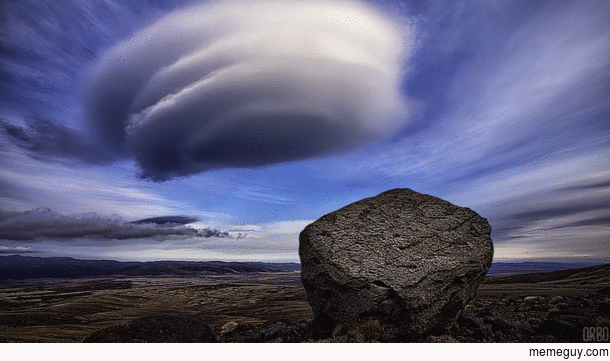
Another cool, more irregular type of cloud is 🛸lenticular clouds🛸 AKA UFO clouds. As mentioned previously (in CLOUDS AGHHHHHHHHH YAYAYAYYA!!!! Part 1), these clouds are a type of altocumulus clouds and have a smooth, disc-like shape. But, this is only their most popular type; they are also associated with cirrocumulus and stratocumulus clouds. In their cirrocumulus form, their least likely form, they simply look like a smoother version of cirrocumulus clouds. Stratocumulus lenticular clouds tend to be lengthier and, what a surprise, smoother as well. (Pretty much, if it’s lenticular, it is smoother than normal.) They form when the flow of dry air sandwiched between two layers of moist air gets disturbed by a mountain. This causes the originally horizontal air flow to go in a wave motion. This gets complicated to explain verbally so I drew a handy-dandy diagram:

What is most special about lenticular clouds is that they appear to stand still. They are sometimes even referred to as standing wave clouds. The thing is, water vapor and air is continuously flowing through the cloud becoming a part of it for a little bit before flowing back downwards and evaporating. To me, this concept was extremely confusing until I heard this comparison: lenticular clouds are like ripples in a stream as water flows over rocks – the ripple stays in the same spot but the water itself is constantly flowing through it.
Next up are 🌨️Virga Cloud Formations🌨️ which “are essentially rain and precipitation strips falling from a cloud that evaporate before hitting the ground” (What’s This Cloud). Luckily, at least for me, this one isn’t as complicated as the previous two cloud types so I’m just gonna leave you with some virga photos and move on.

Now, on to 🌊Wave Clouds🌊 AKA Kelvin-Helmholtz clouds. These rare, short-lived clouds are found among cirrus, altocumulus, cumulus, stratus, and stratocumulus varieties. They tend to form at sunrise or sunset when the bottom of the cloud is in cooler conditions than the top. This means the air is more dense at the bottom and lighter at the top which causes the air at the top to move much faster than the air at the bottom because the air has less to push through at the top. This difference in speed is known as wind shear. “When the upper layer of air is moving at a higher speed than the lower level air, it may scoop the top of an existing cloud layer into these wave-like rolling shapes” (Skybrary).


If you see these clouds, that means the atmosphere is unstable where you are. An unstable atmosphere means the temperature of the air cools rapidly as you go higher. As mentioned in Part 1, this allows for the vertical growth of clouds which also means cumulonimbus clouds can form. That is why unstable atmospheres are associated with stormy weather. On the other hand, a stable atmosphere means the temperature of the air cools slowly (and might even warm up at times) as you go higher in elevation. This blocks the vertical growth of clouds. (Met Matters)

Finally, I wanna talk about ✈️ Contrails ✈️ AKA condensation trails. Contrails are part of the homogenitus clouds group which refers to clouds caused by human activities which includes emissions from factories as well as contrails which are formed (What’s This Cloud). Contrails form in two ways: aerodynamically and by the exhaust (Boldmethod). When air flows over the wing of a plane, it starts to decrease in pressure which causes the temperature to drop. As the temperature drops, moisture and exhaust that surround the plane can condense forming a cloud. These contrails are known as short-lived contrails because they are, you know, short-lived. The exhaust contrails form when the plane’s exhaust, which emits hot vapor and small particles like aerosol, and this hot, moist air hits the very cold (-40 degree C) local air and it condenses, freezes, and forms a contrail.

The exhaust contrails tend to be persistent or persistent spreading contrails because the last for good, long while and might even condense and spread outwards if it is humid enough. Speaking of which, scientists use contrails to figure out how humid it is high up in the atmosphere — short-lived = a little humid; persistent = quite humid; spreading = super humid (NASA). Finally, they tend to be formed way towards the top of the troposphere where planes reach their cruising altitude.
Recently, on a flight back from Burlington, Vermont (yay college visits🥲), I was looking out the window the whole flight because I didn’t download anything to watch and only brought school reading, which, of course, was perfectly fine by me considering how much I love clouds and OMG THE CLOUDS FROM ABOVE! Firstly, as my shameless segue way to show cool pictures and videos I took from the plane, here is a quick video I took of another plane’s contrail forming right above the plane I was in.
My best guess is that the contrail in the video is from the exhaust and is persistent or persistent spreading. I wasn’t able to watch the contrail to see if it stuck around or spread that much but it was so cool seeing a contrail form about an hour after writing about contrails right here in this blog while waiting at the airport😌.
Now, I also took some INCREDIBLE time lapses, not to toot my own horn, as the plane was landing. (The reason it is split into two videos is because my arm got tired after holding up the phone for 20 minutes straight.) To summarize the time lapses, I started after I saw the coolest cloud I’ve ever seen in my entire life (which is saying a lot because I am always looking at the clouds). Then the plane went from above a storm to under it. The second time lapse starts up with a gorgeous view of a sunset coming under the clouds as the storm is breaking up. Finally, the time lapse ends with the blue and golden sky peaking through the receding cloud cover. I actually think that I saw heaven in the sky. Anyways, now that I’ve gotten you all excited, here are the time lapses.
Also, here is a good picture of the Coolest Cloud I Have Ever Seen In My Entire Life:

My best guess for what was going on in this cloud is that it was forming the wave clouds that are a tell-tale sign of atmospheric instability but the wind pushed the crests of the waves over so it forms this cave-like structure. I don’t really know though. If you happen to be a cloud expert or know one, please ask them what they think is happening and let me know. Thanks!😊
That’s all for now. Next up in the cloud saga: Part 3 – Clouds and Climate Change.